Departing from the livestock heartland of northern Gran Canaria, the village of San José de Caideros, this route leads us through ancient rural paths flanked by centuries-old chestnut trees, natural viewpoints, and agricultural terraces that still retain the charm of the past. The first stretch ascends gently through the Altos del Castañero, a cool and shaded area offering spectacular views of the island’s central mountain range. After reaching the highest point, the trail descends toward Majada Grande, and from there continues downward to the charming hamlet of Montaña Alta, one of the most scenic natural balconies in the region.
A stop at the Montaña Alta Viewpoint provides unforgettable postcard views of northern Gran Canaria, with the ocean merging into the horizon. From here, the trail winds downhill to El Junquillo, finally reaching the endpoint: the Santa Cristina recreational area, an ideal place to finish the day with a break among eucalyptus trees and picnic tables. This hike combines the best of the northern mid-mountains with rural history, green landscapes, and authentic, less-traveled corners of the island.
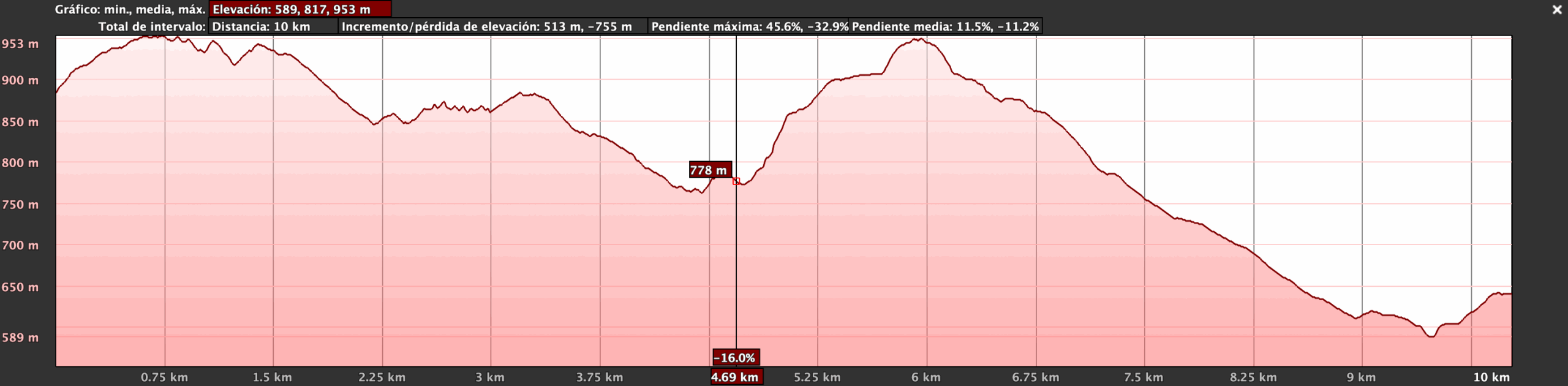
The route begins in the small village of Caideros, located in the midlands of the island’s northwest—a traditional agricultural and livestock-farming area. The trail runs from west to northeast across the municipalities of Gáldar and Santa María de Guía, crossing several ravines before reaching the Santa Cristina Recreational Area.
Early on, the trail intersects with the Camino de Santiago at Montaña Acebuche, then continues along the upper reaches of iconic ravines such as Los Manantiales, Inciensal, and Marqués de Abajo. The trail then reaches Montaña Alta and its famous Casa del Queso (Cheese House). From there, after enjoying exceptional panoramic views, the route begins a steady but gentle descent between hills and vegetable crops toward the final destination.
The route is rated as medium difficulty and is suitable for a broad audience, with no technical or dangerous sections. As always, participants are required to bring at least 2 liters of water, sun protection, a hat/cap, and clothing appropriate for the weather conditions. Minors aged 16 and older may participate if accompanied by an adult. All participants are reminded to follow the guides’ instructions at all times.
Technical difficulty: Medium – Well-marked rural trails, with some steep sections and uneven surfaces. Terrain may be slippery in humid conditions.
Physical difficulty: Medium – Significant elevation change (+513 m / -755 m) over a distance of 10 km. Requires endurance but is not overly technical or complex.
Caideros – Mirador de Montaña Alta – Altos de Guía y Gáldar – Reserva Natural Especial de El Brezal
The rural village of San José de Caideros, in the municipality of Gáldar, is one of the most culturally significant farming enclaves in northern Gran Canaria. Known for its livestock traditions, its connection to the production of flor cheese, and for hosting the renowned pilgrimage of the same name, Caideros offers an authentic rural setting surrounded by gentle mountains, traditional homes, and agricultural terraces. The name Caideros refers to steep areas where rainwater and small ravines run through the landscape. This is an ideal place to explore the dispersed settlement pattern typical of the midlands, traditional rural architecture, and the important role of goat farming in the local economy. Its landscape and everyday life make it a perfect gateway to a route filled with memory and living culture.
The Montaña Alta Viewpoint, located in the hamlet of the same name within the municipality of Santa María de Guía, is one of the most photogenic spots in the island’s north. From this natural vantage point, you can see the ravines, hills, and ridges of the island’s northwest, and even the coastline and the Atlantic Ocean on clear days. Beyond its scenic value, the viewpoint is ideal for interpreting the region’s geography: the network of ancient trails, the routes used for transhumance, and the historical boundaries between municipalities. It is also an excellent spot to talk about local cheesemaking culture, as Montaña Alta is a key site for the production of flor cheese, a product with Protected Designation of Origin status.
This area, straddling the border between the municipalities of Guía and Gáldar, has historically been one of the most active zones for traditional herding. Its gentle summits, rich pastures, and proximity to rural settlements have supported a deeply rooted livestock culture. Along the trail, you may see old majadas (livestock enclosures), small corrals, family-run cheesemaking facilities, and trails once used by herders to move their flocks. Flor cheese, made with natural coagulant from the thistle flower, symbolizes this tradition, as does the use of caves for maturing the cheese. This stop invites reflection on cultural landscapes, inherited knowledge, and sustainable rural economies.
The El Brezal Special Nature Reserve is one of the last remaining stands of fayal-brezal heath forest in Gran Canaria—a transitional ecosystem between laurel forests and pine groves that was once widespread across the island. This protected natural area harbors unique plant species such as heather (Erica arborea), faya (Morella faya), ferns, and a diverse community of birds and invertebrates associated with this moist mid-altitude habitat. In addition to its ecological value, El Brezal holds cultural significance, as many of its trails were historically used by herders, woodcutters, and farmers. Found at the final stretch of the route, its dense vegetation and cool air contrast sharply with the previous landscapes, offering the perfect conclusion to the experience. This area is ideal for reflecting on the conservation of island biodiversity, the impacts of climate change, and the role of protected natural spaces as refuges for life and as a living memory of Gran Canaria’s original landscape.


This route begins at the top of the majestic Tamadaba Pine Forest, one of the oldest and best-preserved natural areas of Gran Canaria, located within the Natural Park of the same name.
This route begins in the spiritual heart of Gran Canaria: the Marian village of Teror, a starting point steeped in history, faith, and culture.
Departing from the livestock heartland of northern Gran Canaria, the village of San José de Caideros, this route leads us through ancient rural paths flanked by centuries-old chestnut trees, natural viewpoints, and agricultural terraces that still retain the charm of the past.
This linear route connects the traditional village of Tunte (San Bartolomé de Tirajana) with the bottom of the spectacular Fataga Ravine, ending at the aboriginal settlement of Arteara.

Immerse yourself in relaxation, explore the coastline, discover new routes and get into the most captivating nature.


Subscribe to our newsletter to receive all the latest news about the Gran Canaria Walking Festival.